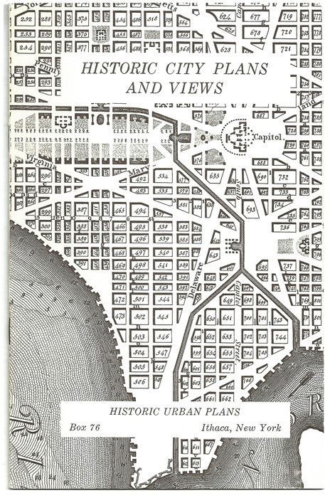
On March 18, 1999, Swann Galleries in New York held an auction of the map collection of Professor John W. Reps. Titled Fine Maps & Views from the Collection of John W. Reps, the auction was proceeded by a private preview and lecture by Prof. Reps on his years of map collecting, which began just after WWII in Europe. This collection formed the basis of his company, Historic Urban Plans, founded in 1964. Prof. Reps mentioned by name several of the maps in his collection that were reproduced by the company; these maps are underlined and linked to our catalog to illustrate his text. Used with permission, 2005.
THE REPS COLLECTION OF MAPS, TOWN PLANS, AND VIEWS
By John W. Reps
Having never consigned a collection for auction, I am a little uncertain about how we should proceed with this pre-auction event. Although it sounds a little like “How I spent my summer vacation,” the suggestion from Swann that I say something about how, when, where, and why I became interested in maps seems an appropriate beginning.
It was not the Boy Scouts, although I did my share of blundering around the Ozark hills with a compass when I was growing up in southwest Missouri and went to Scout camp every summer. Instead, it was a happy accident at Dartmouth College to take a course in Geography. That led to honors work with the professor my junior year in a project that marinated me in maps studying the development of a township in Vermont. From colonial maps of Vermont and 19th-century atlases of Windsor County to modern topo and soil maps – I used them all.
In the summer of 1942 I worked for the Boston office of NRPB [National Regional Planning Board], where maps were in use daily, and in the fall I took a course in map reading and air photo interpretation in preparation for what I hoped would be my military assignment. Eventually I was assigned to the new Buckley Field, Colorado War Intelligence Room and helped to create its exhibits. My duties were to give frequent briefings to trainees and base personnel on the progress of the war and to prepare and change map exhibits showing conditions in the European theatre of operations.
Early in 1946 I came to Cornell University as a graduate student in city planning, a field in which maps were then essential to display results of studies and proposals. Still, I was not yet a collector of anything other than modern maps. That changed when, in March, 1947, I went to Britain to observe British town planning, for the first three months as a research student at the University of Liverpool and another three months of travel and interviews.
It was on a visit to Edinburgh that I bought my first antique maps at the bookshop of James Thin. This was Smith’s Atlas of English Counties, published early in the 19th century. That summer in London I wandered into the Francis Edwards bookshop on Marylebone High Street, then the center of the British antiquarian map trade under the direction of R.V. Tooley. For 10 shillings ($2.00) he sold me a town plan of New Orleans, thus beginning a contact with Tooley that lasted for many years.
At that time Tooley’s office was literally stacked to the ceiling with maps. Huge amounts of antiques of all kinds – including maps and prints – came on the market as Britain slowly recovered from six years of wartime disruption. And, of course, prices were low. In Salisbury I splurged and for 3 guineas (about $12.50) bought the folio-size, multi-volume Rapin History of England with dozens of engraved town plans. Many of these had been skillfully copied by the 18th century publisher from Blaeu’s town atlas of the United Netherlands.
In July 1947 I spent a week in Paris. There the bookstalls along the Seine were overflowing with maps. Any knowledgeable person spending $1,000 then and holding on to the collection would be a multi-millionaire today. I wasn’t very knowledgeable, and my source of income was the G.I. Bill with its monthly stipend of $65.00. So, with fine impartiality – but for never more than $1.00 – I bought originals and reproductions alike, not really knowing the difference.
 Homann’s Western Hemisphere was one purchase that later hung in my parent’s living room for 20 years. The real find – although I did not know it at the time – was the beautiful Sanson map of North America of 1650. As many of you know, this is the first printed map to show all five of the Great Lakes and one of the earliest maps to depict California as an island. For a good many years I was able to look at this daily as it hung on the wall by our dining room table.
Every other bouquiniste seemed to have a copy of the 1755 Robert map of Virginia and Maryland – the reduced version of the large Fry and Jefferson engraving. I came away with another nice $1.00 purchase.
The academic year 1950-51 found me once again in Britain as a Fulbright student, following three years as Planning Director of Broome County, New York. I bought some other items from Francis Edwards, including the John Speed map of Flintshire with its inset plan of Flint – one of the several new towns planned in the 13th century by Edward I. During a long stay in Paris before returning to the U.S. I again browsed the bookstalls along the river as well as the many print shops on the Rue de Seine.
Academics don’t get paid much, but, at least at Cornell, where I began to teach in 1951, they do get sabbatic leaves after six years, and in Europe in 1958-59, again in 1965-66, and for three months in 1973, I began to collect seriously.
In those years European prices of American material were still much lower than in this country, as were prices of European town plans. There were new dealers in London and Paris, the proprietors of shops in Vienna, Bonn, Cologne, and other places in Western Europe offered American maps at what now seem like give-away prices.
The 1965-66 sabbatic took us to The Hague, and there and in Amsterdam I found many of the better items in the collection. A year earlier I had started publishing facsimiles of town plans under the business name of Historic Urban Plans. For ten years or so I plowed back into the business all net income, using some of the funds to buy old maps for eventual reproduction.
There were many map and print dealers in The Hague and Amsterdam, as well as a number of antique shops whose proprietors knew and cared little about maps. And – the Dutch guilder at $.28 was very cheap. I bought two American maps for about $5.00 each from a little antique shop two or three blocks from where we lived. And I remember paying 1 guilder for a Braun and Hogenberg in another antique shop – both shop and engraving in pretty awful condition, however.
In The Hague I met Meyer (Max) Elte, whose shop was the very model of what a rare book and print establishment should look like. Max Elte was a highly respected dealer and scholar, and he gave me free access to his fine reference collection. He also had masses of material stored behind the closed cabinet doors that I always aimed for first. These were still marked with pre-war prices. I always gave Elte a chance to adjust these figures, but he declined. He still made a profit, for he went regularly to London to buy Dutch maps from Tooley where – Elte told me – Tooley would put a pile of maps on a scale and price them by weight.
 Since I have mentioned prices, let me add a few more words on that subject. For many years I refused to tell Mrs. Reps what I had paid for a large and highly decorative map that still hangs on a wall in our house. I bought this from a shop in Paris on the Rue de Seine in – I believe – 1966. The price was $40 – at that time the most I had spent for a single item. Indeed, except for not more than a dozen items in this auction, $300 was the most I have ever spent for a single map – and that includes the wonderfully detailed John Rocque 24-sheet map of London.
But although I bought maps and plans for my business, like most other collectors it was not some ultimate financial reward that motivated me. Instead it was the challenge of the hunt, the thrill of recognizing the cartographic, historical, or decorative importance or appeal of a map or plan, the satisfaction of recognizing something the dealer had not, the pleasure of looking at a beautiful example of composition and engraving, and the satisfaction of learning from what the map or plan displayed. I had other uses for many of the maps and plans – as illustrations used in classroom lectures on the history of urban planning and for the books I wrote on the history of American city planning and on 19th century urban iconography.
Now let me comment on some of the items that will be auctioned tomorrow. Because my first interest was in town plans, and this is St. Patrick’s Day, I choose to start with three Irish city maps. The Cittie of Limerick and The Towne of Youghall are two of the three plan-views published in London in 1633 as plates in Thomas Stafford, Ireland Appeased and Reduced. Or, an Historie of the Late Warres of Ireland. Sir Walter Raleigh was once Mayor of Youghall, and the town is believed to be the place where the potato was introduced into Ireland from the New World.
The Braun & Hogenberg sectioned sheet titled Gallway. Dublin. Lymirick. Cork. is one of more than two dozen plans and plan-views from this first atlas of cities – in this case from Volume VI, issued in 1617. This gives me an excuse to talk a bit more about the wonderful images of towns that Georg Braun and Franz Hogenberg published in six volumes, beginning in 1572.
The Cambridge plate combines a street plan with perspective images of every building. This was a style that Braun favored. In introducing one of the atlas volumes he wrote: “Towns should be drawn in such a manner that the viewer can look into all the roads and streets and see also all the buildings and open spaces.” For a city planner, what could be better?
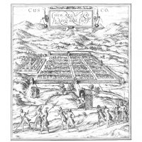 I later bought more than two dozen other plates from this remarkable and unrivalled source. They include those of Chester, Paris, Venice, Palma Nova, Besancon, Blois, Avignon, Edinburgh, Milan, Cairo, Istanbul, Rab (now Gyor) in Hungary, Mexico City and Cuzco in Peru, the only American cities in the atlas. Everyone who knows this splendid source of information about how cities looked in the Renaissance has a favorite or two. One of mine is Moscow, a print acquired in trade from Harry Shaw Newman. When this was published in 1575, St. Basil’s had been built but it does not appear in this print because the delineation is taken from Sigsimund von Herberstein’s illustrated book on Moscow published a quarter of a century earlier. Note the skiers approaching the Kremlin over what would become Red Square, images taken from another plate in Herberstein’s book. The Kremlin churches appear in recognizable form. The hundreds of what look like pre-fabricated houses are clearly not entirely accurate representations of what the city must have looked like, but on my first visit to the USSR in 1959 – earlier in the year I acquired this engraving – I saw and photographed many similar wooden houses that since then have been demolished.
A few years later in Copenhagen, I was able to buy the Moscow plan-view that was in the last volume of the Braun-Hogenberg atlas of 1617. These two belong together, along with another map of Moscow published in Prague in 1808.
 Other European town plans come from other artists and publishers. Cornelius Drebbel, inventor and scientist, drew a wonderful depiction of Alkmaar in 1597. Decades later Blaeu copied this line by line for the images he used in his splendid two-volume atlas of towns of Holland and Belgium.
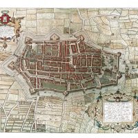
Frederick De Wit’s plan-view of Delft, published ca. 1695, was lifted from Blaeu’s image of the town that Blaeu based on the Braun-Hogenberg engraving. De Wit’s record of this beautiful Dutch town was a wonderful reminder of our year in The Netherlands. On two occasions I lectured at the School of Architecture, then located on one of the canals across from the great church you can see at the center.
I bought as many Amsterdam plans as I could afford. Guiccairdini’s depiction of 1566 is the earliest, an image on which Braun and Hogenberg relied. Here is the medieval city that began as a tine village huddled around the dam on the Amstel River.
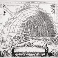 In the city’s prosperous golden age it expanded on land reclaimed and drained by canals that paralleled the Amstel River. Then came the great ring canal plan begun at the end of the 16th century. Visscher’s map of 1670 shows this project at the half-way point. An even larger map by Visscher’s widow ca. 1710 documents the completion of the massive city planning effort on land acquired by the municipality.
Homann’s plan of St. Petersburg in 1718 records the early years of Peter the Great’s amazing feat of town planning and building on a swampy site whose only virtue was its fine natural harbor. Here you can see Nevsky Prospekt in its early phase of development leading outward from the Admiralty on the river.
The De Rubeis map of Rome published in 1630 but showing the city as it appeared at the time of the Roman empire is a wonderful companion to the Covens and Mortier one-sheet version of Falda’s 12-sheet Rome in 1676. Together they tell us almost more than we can grasp of this city’s history. I bought them in Salisbury, England, and Amsterdam, and perhaps tomorrow someone will see that they remain together.
In 1754 Delagrive produced his very detailed map of the Ile de la Cité, the ancient heart of Paris. With this at hand you can take an imaginary stroll down every street, alley, and lane in this historic island from the Pont Neuf at one end to the narrow footbridge leading to the Isle St. Louis at the other. Delagrive’s large map of Versailles is equally detailed.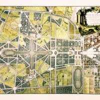
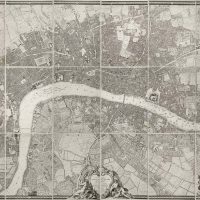
But for even more detail of a major city there is no rival to John Roque’s 24-sheet Plan of London and Westminster. He spent years in its surveys, drawing, and engraving before publishing it in 1746 at a scale of 200 feet to the inch. If assembled, this landmark of urban cartography would measure more than 7 x 13 feet. It’s the nearest thing to London without actually being there.
The collection includes several plates from Blaeu’s Theatrum Sabaudiae. One of these – Cherasco – depicts a symmetrical fortified city laid out in conformity to the theories of Renaissance military engineers.
Another Blaeu town plan from this same source shows Turin from whose core of rectangular streets flows the line first surveyed by the Romans. The great radial boulevard cutting across the grid is an example of Renaissance urban design. I used this as an illustration in one of my books on Washington, for L’Enfant, the planner of that city, had borrowed of map of Turin from Thomas Jefferson before coming up with his own city plan that combined radial streets with the grid.
 L’Enfant probably knew of Christopher Wren’s plan for rebuilding London after the great fire of 1666. I was happy to acquire John Gwynn’s version of that design that he published in 1749. Its text at the top includes the not altogether accurate caption containing the phrase “unhappily defeated by faction”. There is another rendering of Wren’s plan, together with three plans by John Evelyn on a two-sheet set published by the London Antiquarian Society.
Working on my first book on American city planning history, The Making of Urban America [1965], focused my collecting attention on other town plans and views. I love them all, but a few have special meaning. The deBry engraving of Santo Domingo published in 1600 shows the earliest surviving town of European origin in the Western Hemisphere, dating – on its present site – from 1502. We see it here when Drake attacked in 1586, and its orderly plan is exactly the same today.
Twenty-two years before Drake’s attack a group of French Huguenots founded Fort Caroline in Florida, not far from modern Jacksonville. A Spanish force from St. Augustine massacred nearly all the French settlers but this colonization effort is commemorated by one of the gems of the National Park Service. It consists of a full-size replica of the fort based on this engraving of 1591 by Theodore deBry who had used a drawing by Jacques Le Moyne.
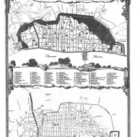
 I used the orderly and distinctive plan of New Ebenezer, Georgia to illustrate an article (and later, a book chapter) on Savannah and other early Georgia settlements. This version with a map of Georgia engraved by Lotter publicized the Georgia colony on the European continent. Oakley’s fine engraving of Quebec in 1758 reveals a quite different urban pattern. On the confined river-level site Champlain began settlement in 1608. A hundred and fifty years later it was somewhat larger, but it was in the upper town that most development took place. The parquet-like pattern you see there resulted from subdivision of their lands by the several religious orders that had received land grants.
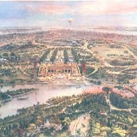 Among the several American views, I am particularly fond of John Bachmann’s wonderful Central Park. This skilled bird’s-eye view artist-publisher issued this lithograph in 1865. We are looking south from a point above and slightly to the east of The Ramble, with the lake and The Terrace beyond. Central Park was New York’s finest achievement in urban planning and one that began a national movement as other cities sought to keep up with New York’s pioneering effort to bring nature into the urban scene.
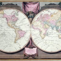 I never got hooked on world maps, possibly because those by Ortelius, Mercator, Blaeu, and other big names were so expensive. Those that came my way I gave to the Cornell University library some years ago, but until now I could not bear to part with the Laurie & Whittle map of 1808. It marks the transition from the highly decorative – sometimes highly imaginative – style to the leaner, cleaner, and more scientific approach to cartography. For me, it has that ideal balance that gives it a special character.
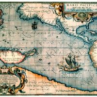 Not quite the world, but more than a hemisphere are two classic maps of the oceans. The earlier is the Pacific Ocean by Ortelius from a 1590 edition of his atlas. New Guinea is huge, as is the enormous land mass along the bottom of the map. In the South Pacific there is a large representation of Magellan’s ship, Victoria, the first to circumnavigate the globe.
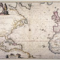 Jansson’s map of the Atlantic Ocean appeared 70 years later. I was happy to provide of transparency of this for use as a dust jacket illustration of the first volume of Donald Meining’s magisterial work, The Shaping of America.
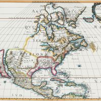
You will find many of the great atlas sheet maps of the Western Hemisphere represented: Munster of 1540 (far less common than his revision issued ten years later with the overprint in set type, “Die Neue Welt”); Ortelius of 1570 with the famous South American bustle that later editions would eliminate; Mercator of 1595 by his son; Hondius of 1630; Blaeu of 1635; Visscher of 1670; Valk of 1690; and Homann of 1720.
Of the North American maps, I have already mentioned the one by Nicolas Sanson in 1650, but earlier and larger was the Jansson’s, first issued in 1638, and – as in this version – with Jansson’s name added in 1647. Tooley points out that this and Jansson’s map of New York and New England represented the “first attempt in Holland to add lakes connected to the St. Lawrence.”
There is the De l’Isle map dated 1703, but in its second state issued after 1708 and before 1718. As most of you know, his maps of America were enormously influential, another way of saying that most of his contemporaries and those who followed freely copied his delineations.
At about the same time Herman Moll issued his North American map, retaining the idea of California as an island. Moll used the margins of his maps for all kinds of extended notes and illustrations. In this case we have a look at codfish drying in Newfoundland, placed above a set of small harbor maps.
Of the maps of the United States, by far the most important, although perhaps not so well known, is Arrowsmith’s enormously detailed, 4-sheet map. Because of its size I have no slide of this. It went through several editions, but mine is the first edition, first state dated January 1, 1796 – an uncommon version not often encountered. Unlike most of the Arrowsmith maps that one sees, this has not been laid down on linen and folded. The color wash and outline color is surely that applied in the Arrowsmith shop.
Another less well-known map is titled Carte du Mexique et des Etats Unis d’Amerique. This is one of the several maps of America that owe their origin to Guillaume De l’Isle – in this case his map of 1703 as revised by his son-in-law, J. A. Dezauche, 80 years later.
I found maps of the various regions of North America particularly attractive and fascinating. The list of those in the collection is long, but here are some examples of the variety that can be found.
One is the rarest is de Fer’s large map of California, showing it as a huge island. According to the text, the map was made for the Viceroy of New Spain in 1695. It was evidently not published until 1720 for security reasons. The empty cartouche at lower left may indicate an intermediate issue.
Was California an island or not? Robert de Vaugondy in 1770 traced how various cartographers had dealt with this matter. You can see here five versions whose authors or sources are identified at the upper right.
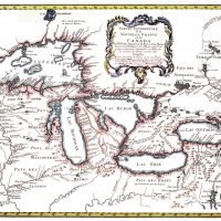 Moving to the upper mid-West, there is Bellin’s map of the Great Lakes as issued in 1755 in Nuremberg by the heirs of J. B. Homann. Bellin’s original depiction of 1744 on a smaller scale is also a part of the collection. This map comes complete with two mythical islands in Lake Superior.
De l’Isle’s map of what he called Louisiane is one of the classics of American cartography. This is the second state of the map as re-engraved in Amsterdam in 1733 to include New Orleans, a town founded in 1718, the year the map was first published in Paris.
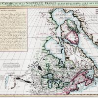
Canada is well represented by both maps and town plans. One that combines both is the famous one by Captain Carver. It depicts the English province of Quebec after the Treaty of Paris in 1763 that brought an end of the French & Indian War. Inset plans of the cities of Quebec and Montreal provide additional information.
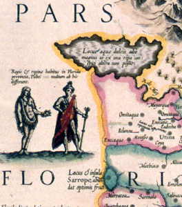
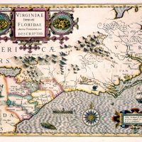 My choice among the maps of the Southeast is the great Hondius map of 1606. Hondius based the map on manuscripts drawn by John White in 1585 and Jacques Le Moyne in 1564. There is an intricate decorative strap-work cartouche in which images of two Indian villages appear, miniature versions of Le Moyne’s depictions that deBry published a few years before Hondius prepared his map.
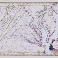
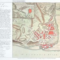
Pierre Mortier’s large and detailed map of 1695 that focuses on the Chesapeake Bay had a special meaning for me. I spent a good part of two summers in that region doing research for my book on urban origins in the Tidewater Colonies. Colonial Williamsburg published that book, and I was able to thank them by giving another impression of this map that I had been able to acquire. Don’t tell them, but I kept the better of the two.
Bleau’s map of Virginia is a particularly handsome impression of what has always been a popular example of cartographic artistry. But does Bleau deserve the credit? If you look closely at the signature you will see that it once read “Hondius” but was not completely erased. A similar but not identical map of Virginia by Hondius is also part of the collection for those who want to compare them.
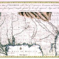 Another southern map that has been useful to me in tracing settlement patterns is Bowen’s Georgia, a generous delineation that extends to the Mississippi River. The one you see here is colored, but the collection includes an uncolored impression in pristine condition.
Jansson’s New England is the first state of his map as published in 1637. Ten years later the simple, heart-shaped cartouche was replaced with a more elaborate design containing a new title. This is the first Dutch map to show large lakes as part of the St. Lawrence River system, and Karpinski states this is the first printed map to show Lake Superior.
Eighty-five years later Homann issued his map of the Northeast. Germany, of course, was not a colonizing power in North America, and Homann had to base his information on secondary sources. This has the typical German coloring that one also finds on the maps by Seutter and Lotter.
Some decorative appeal may be lacking from Tanner’s work, but his regional maps of America are wonderful examples of cartographic accuracy and detail. This is a typical examples of the sheet found in the large folio atlas he issued in 1820.
Who can resist the maps of the Caribbean? Aside from Santo Domingo, Puerto Rico, and the Virgin Islands, I have not traveled in this area. But maps have allowed me to do so vicariously.
One of the earliest is the delineation of the area by Ortelius in 1579. This sectioned sheet contains a portion of the western coast of Mexico in the upper half.
Visscher’s large map, like that by Bleau and others, includes all of the Caribbean Islands as well as parts of the coast of Mexico, and Central and South America.
Coronelli’s map that J.B. Nolin engraved and published in 1688 shows the entire region, and features decorative elements that draw one’s eye away from the distorted rendering of the islands themselves.
The opposite is true of the superbly detailed chart of the southern tip of Florida and the Bahamas that William Faden published in 1794. Here, decoration has given way to the serious business of navigating these difficult waters.
Among the Caribbean material there are also the six two-stone lithographic views of towns and scenery in the Virgin Islands published as book plates about 1850 in Copenhagen by Em. Baerentzen. He was an apprentice to an apothecary in the Danish West Indies who later turned to art and lithography. Baerentzen moved to Copenhagen to begin the Lithographic Institute in 1837 and used these Virgin Island scenes in one of his books.
Not truly Caribbean is a map that would be a strong contender in any competition for the most exuberant title cartouche. This is Blaeu’s lovely map of Bermuda. This made its first appearance in 1635 and was in various Blaeu atlases for another thirty years or more.
The impression in the collection must have been one when the plate was young, and the brilliant color may have been added in the Blaeu shop instead of being farmed out to orphanages. Just look at Neptune rising from the sea.
Finally, I want to call attention to some sleepers (not, I hope in this group) that might be overlooked.
Henri Chatelain’s Atlas Historique, the first volume of which was published in Amsterdam in 1705, is the source of five American maps in the collection. These deserve far more recognition than they normally enjoy. The quality of the engraving is unsurpassed – superior, in my opinion, to those of Bleau that so many books hold up as the model of excellence. My favorite is one that compresses into a single sheet the huge four-sheet and very rare map that de Fer issued in 1719. 
There are three maps by Louis Capitaine, the personal cartographer during the American Revolution to General Lafayette. Only one of these is signed, but all come from editions of Rochefauld’s travels, published in Paris ca. 1799. Aside from this interesting association, they are all nicely engraved and far more detailed than the usual map folded inside the covers of a travel book, information based on Capitaine’s own first-hand knowledge of the places shown and the roads that connected them.
Another Frenchman, Edouard de Montulé, was responsible for two cartographic “Firsts,” both published in Paris in 1821 in an atlas accompanying his book of travels.
His map of the United States is, I believe, the earliest map of the country to be printed in the medium of lithography.
Montulé’s view of New York is – I believe – the earliest American city view to be printed lithographically. To make it even more unusual, it was done with two stones, one to add the buff color over the basic black and white of the drawing. His foreword of this volume begins: “I should not have published these letters without the aid of lithography. The easy execution of this process suggested to me the idea of passing along to my friends and to the public some of the sketches I have made in different countries. Several persons of some repute in the arts have assured me that a collection of views of America … would not be without interest; that is what made me decide to have them printed…”
An African map in the collection was too large for me to photograph. This is Pierre Mortier’s double-folio map of the Cape Verde region of Western Africa. It appeared in the only edition of his maritime atlas of 1700. In addition to its great detail and fine old color, its special – and tragic – importance is the inset map of the Island of Goree. It was from this infamous place that millions of African slaves were herded on ships for the voyage to America. There is now a museum on the island that preserves the grim evidence of a practice that nearly 300 years after this map appeared we cannot forget nor forgive.
From the tragic, now look at the evidence of a major American land swindle. In 1787 the Ohio Company and the Scioto Company bought at wholesale prices 5 million acres of the Federal public domain. Congress approved this after retail land sales of the newly surveyed Federal lands in Ohio – the first seven tiers of townships – failed to yield expected revenue. The Scioto Company was a pure speculation whose officers sold land in France with promises that French immigrants would be transported to a beautiful city being built on the Ohio River.
Five hundred French arrived in Alexandria, Va. in 1800, had to make their own way to the site, and found that no provision had been made for any city, town, or even frontier log cabins. Eventually the Ohio Company, composed of settlers from New England, moved the French to part of their land and provided housing in a new town they named Gallipolis. It was not the first, nor would it be the last of notable land swindles. I have never been able to trace the origins of this map, but I am certain that it was used in France to promote land sales.
Finally, to bring this to a close, I want to introduce you to a fascinating behind-the-scenes example of American lithography and a product of a New York shop. This is an untitled, undated, and unsigned view of Central Park, probably by Charles Magnus in the late 1860s or early 1870s, and almost certainly an early proof. On the verso is a facsimile of the James Lyne plan of New York in 1731 that is signed by Magnus. Printers still often use for proofing the clean verso of excess runs of other jobs, and here I think that Magnus did just that on unsold, or imperfect copies of his earlier Lyne facsimile.
No collection can be built without the help of dealers, and I have enjoyed my relationships with many, both in Europe and in the U.S. In addition to those I have mentioned – R. V. Tooley, Max Elte, and Harry Newman – there have been many others: Ken Nebenzahl, Judy and Jim Blakely, and Warren Howell in this country; Jonathan Potter, Henry Stevens Sons and Stiles, and P. J. Radford in Britain; Louis Loeb-Laroque in Paris; and several Dutch dealers, just to name a few. And, although I may never have purchased from other dealers, I have learned from their catalogs and am grateful to them for the information they have provided and the opinions they have offered.
There is a great deal more that I could say, but perhaps this is enough. For those of you who will be here tomorrow I can only suggest – using the words of Chairman Greenspan – that you bid with irrational exuberance. To private collectors who are successful bidders, I wish you the same pleasure and joy that these maps have brought to me, and to those of you who are dealers, please see that these maps find their way to appreciative owners.
~ The End ~
Living History
Historic Urban Plans recently joined the Association for Living History, Farm and Agricultural Museums (ALHFAM), an organization that supports the preservation and interpretation of places and cultures associated with our pre-industrial past.
 As a vendor that’s had long-term relationships with several open air museums in the Northeast and Southern United States such as Colonial Williamsburg – we want to support ALHFAM’s mission to bring history to life using exciting, hands-on teaching methods. Traditional building, farming and manufacturing; heritage plants; oral history and authentic reenactment all this and more is important to keeping our past alive and relevant to visitors today.
Our reproduction antique maps are a rich source of information that can be key to the interpretation of a place, people or cultural practice. Whether the map depicts Native people in the early years of North American exploration, like this detail from Jodocus Hondius’s 1606 map of Virginia and Florida, or a survey of the terrain surrounding early settlements in coastal Virginia, such as this section from the seminal Jefferson-Fry map of 1755, 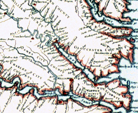 these were actual physical objects created and used by people in the past to make sense of the world around them.
Visitors to living history museums can see, touch, and experience life as it was lived in the past. Our maps are a piece of that past that visitors can take away with them to continue a lifelong process of learning and understanding.