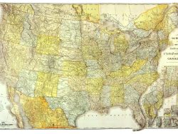
United States 1861 – Souvenir Series

$16.00
The east half of the country is shown on this highly colored map, extending to about the 103rd Meridian. It marks “the Military Stations, Forts, &c.,” as well as Pony Express, U.S. Mail routes, railroads, turnpikes, and canals. J. H. Colton prepared it for the “Rebellion Record”, a short-lived periodical subtitled a “Diary of American Events,” published in New York by G. P. Putnam.
Size: 14 3/4 x 15 3/4 inches – Color, Text-Weight Paper