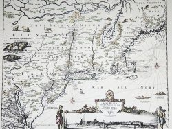
New York and New Jersey 1776

$47.50
This superb map drawn by C. J. Sauthier is a detailed record of urban settlement in the northeast at the time of the Revolutionary War. It includes the area between Boston on the east and Cayuga Lake on the west, centered on the Hudson River Valley region and showing the roads, forts, rivers, mountains, and lakes with great accuracy. Of special interest is its depiction of the upper Connecticut River and Lake Champlain regions, with Vermont being shown as part of New York.
Size: 25 3/4 x 20 1/2 inches – Color, Text-Weight Paper