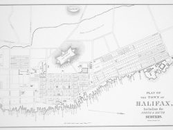
Halifax, Nova Scotia 1750

$37.50
In the struggle for supremacy in North America the English planned Halifax as a major base to counter the French strongpoint at Louisburg. This engraving by John Rocque shows the location of the town on a large scale chart of the great natural harbor. At the upper right is an elaborate title cartouche containing a dedication to the Earl of Halifax. At the lower left is an inset plan of the town with a legend identifying its principal features. Halifax had been in existence only one year at the time this map was issued. It is one of the earliest and perhaps the first printed depiction of this important Canadian city. The unusual vertical format and the fine quality of the engraving make this print as attractive to display as it is informative to study.
Size: 22 1/2 x 17 inches. Black & White, Cover-stock paper